
भू - तकनीकी इंजीनियरिंग
भू-तकनीकी इंजीनियरिंग प्रयोगशाला विभिन्न बुनियादी और उन्नत प्रयोगशाला उपकरणों से सुसज्जित है, जैसे प्रत्यक्ष कतरनी परीक्षण उपकरण, कंसोलिडोमीटर, वेन कतरनी परीक्षण उपकरण, सीबीआर, आदि और चक्रीय त्रिअक्षीय परीक्षण जो एक अधिक सामान्यीकृत और उन्नत कतरनी शक्ति मूल्यांकन उपकरण है जिसका उपयोग स्थैतिक और गतिशील दोनों लोडिंग के तहत, विभिन्न जल निकासी स्थिति के साथ किसी भी प्रकार की मिट्टी का अध्ययन करने के लिए किया जा सकता है। शिक्षण के अलावा, प्रयोगशाला के विभिन्न शोध समूह वास्तविक जीवन के परिदृश्यों से संबंधित प्रमुख समस्याओं को संबोधित कर रहे हैं, जैसे रेत के टीलों का प्रवास और शमन अध्ययन, भूकंपीय रूप से सक्रिय और तरलीकृत मिट्टी वाले क्षेत्रों में अपतटीय पवन टर्बाइनों के लिए मोनोपाइल नींव, जियोसिंथेटिक्स का उपयोग करते समय सतह के तापमान में अत्यधिक बदलाव के दौरान भू-तकनीकी संरचनाओं की स्थिरता आदि।
- Stress Path Triaxial Test Apparatus
- Ground Penetration Radar (350 MHz)
Stress Path Triaxial Test Apparatus
The stress path triaxial system is a valuable tool in geotechnical and civil engineering, used to understand soil behaviour under controlled stress conditions. One critical application is in the design of foundations and retaining structures, where understanding the soil response to loading helps engineers predict settlement, bearing capacity, and potential failure modes. By simulating site-specific stress conditions, the system enables more accurate modelling of how soils react to construction loads. In embankment and dam construction, the stress path triaxial system is used to assess the risk of shear failure during different construction stages or seismic loading. It also plays a crucial role in slope stability analysis, especially in identifying progressive failure mechanisms under varying drainage conditions. Moreover, in underground excavations like tunnels, the system helps simulate stress redistribution around the cavity and guides the selection of appropriate support systems. For oil and gas or mining operations, the technique aids in evaluating reservoir compaction and subsidence behaviour. By tracing the path of stresses during loading and unloading, engineers can optimize designs for safety, cost-efficiency, and longevity, especially in complex soil environments or projects with high geotechnical risks.

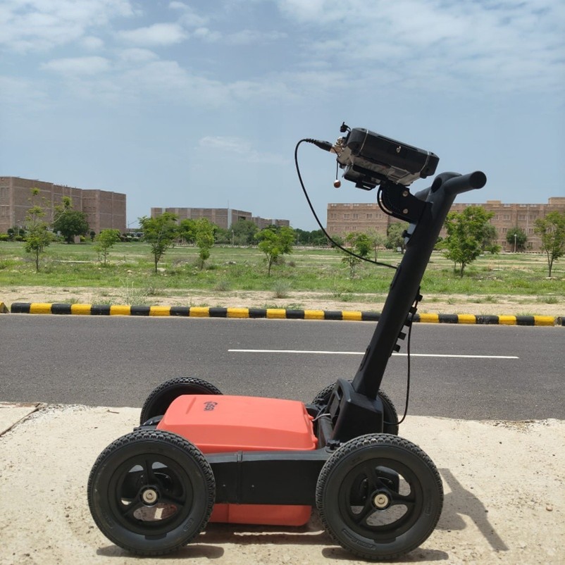
Ground Penetration Radar (350 MHz)
Ground Penetrating Radar (GPR) is a non-destructive geophysical method widely used in engineering for the detection and mapping of underground features. One key application is utility locating, where GPR accurately determines the position and depth of underground metallic and non-metallic utilities such as pipes, cables, and ducts. This prevents accidental damage during excavation and supports effective planning in urban development. GPR is extensively employed in civil engineering projects including highways, bridges, tunnels, and railway tracks, for assessing subsurface conditions, identifying voids, delaminations, and structural weaknesses. In geological and archaeological surveys, GPR helps in identifying natural layers, cavities, and buried artifacts without disturbing the ground. Advanced systems like the UtilityScan Pro by GSSI, integrated with the SIR 4000 control unit and a 350 MHz antenna, can investigate depths of up to 12 meters, making it ideal for both shallow and deep subsurface applications. Additionally, the Radan 7 analysis software enhances data interpretation through advanced visualization and filtering capabilities, enabling precise mapping of subsurface structures.
 |
 |
 |
| वाइब्रेटरी सीव शेकर | जीपीआर | समेकन परीक्षण उपकरण |

|  |
 |
| पृथ्वी प्रतिरोधकता मीटर | चक्रीय त्रिअक्षीय परीक्षण उपकरण | डिजिटल त्रिअक्षीय उपकरण |
 |
 |
 |
| प्रत्यक्ष कतरनी परीक्षण, यूसीएस परीक्षण, और नमूना एक्सट्रूडर | मृदा पोषक तत्व मीटर | तनाव पथ त्रिअक्षीय उपकरण |
 |
||
| पवन सुरंग |